Zebra Canyon is a photographer's dream. Shape shifting walls undulate in synchronous waves, striated with streaks of pink and magenta. The light plays as if in a prism of colorful stone, reflective water, and a sliver of sky. The length of the canyon itself is short, but you could linger for a long time trying to get just the perfect picture of the scene. The hike to get here requires some effort, however, traveling through a sandy wash exposed to the sun and crossing a pool of cold water that guards the entrance. It is a prize well earned. - Overview by Jesse Weber, Outdoor Project.
Description
Take the Hole in the Rock Road 8 miles south from Hwy 12 to a parking area on the right, just past a cattle guard. The trail starts on the opposite side of the road. It is easy to follow until you reach Harris Wash. At this point, follow the cairns up the wash. Once the wash narrows into a slot canyon, you may have to wade through some puddles up to about five feet deep. The canyon quickly narrows to 8-10 inches at its narrowest, with some scrambling required to make it further up. Eventually, the slot runs into a 10 foot high ledge. This ledge can be negotiated with some bouldering/mantling skills, but several more potholes at the top make turning around the better choice.
En cliquant sur "accepter" vous autorisez l'utilisation de cookies à usage technique nécessaires au bon fonctionnement du site, ainsi que l'utilisation d'autres cookies (éventuellement tiers) à des fins statistiques ou de personnalisation des annonces pour vous proposer des services et des offres adaptées à vos centres d'interêt.
Vous pouvez à tout moment modifier ce choix ou obtenir des informations sur ces cookies sur la page des conditions générales d'utilisation du service :
 ForumsToposLes plus belles randosSegments
 Offre Premium
 Connexion





 + m/ m
 36
36 56
56 6 [Légende]
 Pour soutenir VisuGPX, faites le bon choix


 8.05 km
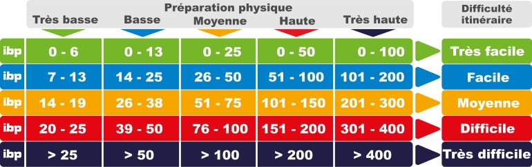
 171 pts
 73 m
73 m 73 m
73 m 1625 m
 1571 m
 1590 m

 02:50:00
 02:49:00
 00:01:00