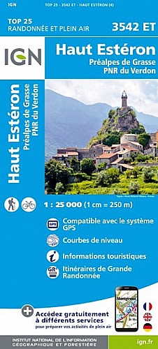
The destination is one of several in the region in which the Ligurians have left their trace. Atop a high, rocky pinnacle, the Castellaras de Thorenc hpendias sweeping views of the surrounding mountains and plains. There are multiple ways to access this summit. One from the south is quick and easy. One from the road on its northern side is direct and relatively easy also. Our group took the third, longer route which is a nice ramble through a forest. Depending on the time of year, this can be combined with a visit to Pas de la Mule, to the west of Col de la Baisse, where a riot of pivoines can be seen. Interestingly, the Department of Forestry is planting thousands of young trees in areas exposed to erosion and degradation by logging.
 Actions
12 km

+388 m/-405 m

04:00

Cliquez pour activer


Cliquez et déplacez la souris sur le profil pour analyser un tronçon (2 doigts sur mobile)
Commentaires
Pas encore de commentaire, connectez-vous pour en ajouter un.
Connectez-vous pour ajouter un commentaire
Longueur et nombre de points

12.29 km

2258 pts
Denivelé et altitude
Calculés avec un seuil de 10 mètres et un lissage sur 5 points

387 m

405 m

1400 m

1118 m

1234 m
Date et durée

13 mai 2021
09:32

13 mai 2021
16:21

06:48:43

04:00:16

02:48:27
Vitesses et denivelés horaires

3.1 km/h
Détail »

5.2 km/h
au km 0.3

274 m/h
1h12m00s

-294 m/h
1h05m37s
| km | Temps | Vitesse | Pause |
|---|
| 1 | 23'20" | 2.6 km/h | 01'25" |
| 2 | 19'56" | 3 km/h | 02'04" |
| 3 | 21'35" | 2.8 km/h | 27'50" |
| 4 | 13'31" | 4.4 km/h | 01'20" |
| 5 | 16'30" | 3.6 km/h | 08'49" |
| 6 | 19'07" | 3.1 km/h | 10'30" |
| 7 | 29'54" | 2 km/h | 69'08" |
| 8 | 18'49" | 3.2 km/h | 17'02" |
| 9 | 16'15" | 3.7 km/h | 08'45" |
| 10 | 21'21" | 2.8 km/h | 04'31" |
| 11 | 17'16" | 3.5 km/h | 09'39" |
| 12 | 16'55" | 3.5 km/h | 02'26" |
Dépense calorique (estimation)

389 Cal
97 Cal/h
Plus

Affichée 163 fois et téléchargée 4 fois depuis le 14.05.21 12:05
Carte + Profil [Afficher un aperçu]
<iframe src="https://www.visugpx.com/zigzV9H0dm?iframe" allowfullscreen style="border: 0;width: 100%; height: 540px;" scrolling="no"></iframe>
Carte uniquement [Afficher un aperçu]
<iframe src="https://www.visugpx.com/zigzV9H0dm?iframe&maponly" allowfullscreen style="border: 0;width: 100%; height: 540px;" scrolling="no"></iframe>

Nous avons pris en compte votre choix.
Vous souhaitez maîtriser les informations qui peuvent être recueillies lors de votre navigation et avez refusé les cookies de personnalisation des annonces, c'est légitime.
Parce que le service fourni par VisuGPX a un coût, accepteriez-vous quand même que nous utilisions des cookies pour vous présenter des annonces non personnalisées ? Ces cookies ne sont pas des cookies de tracking mais de simples des cookies techniques de diffusion qui garantissent le respect votre vie privée.


 Actions
  12 km
12 km +388 m/-405 m
 04:00
04:00

 Cliquez et déplacez la souris sur le profil pour analyser un tronçon (2 doigts sur mobile)
 50
50 92
92 35 [Légende]
 Pour soutenir VisuGPX, faites le bon choix