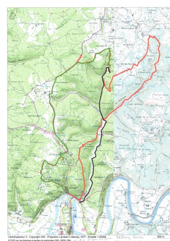
Randonnée d'environ 20km avec un dénivelé positif de 510m.
point de départ décalé, le mieux est de partir du village. Traverser le village et accéder au plateau par un très beau sentier sous les buis. Faire un petit détour pour ne pas manquer les gariottes
 Actions
20 km

+646 m/-656 m

±06:45

Cliquez pour activer

Cliquez et déplacez la souris sur le profil pour analyser un tronçon (2 doigts sur mobile)
 Photos
Commentaires
Pas encore de commentaire, connectez-vous pour en ajouter un.
Connectez-vous pour ajouter un commentaire
Longueur et nombre de points

20.16 km

169 pts
Denivelé et altitude
Calculés avec un seuil de 10 mètres et sans lissage (corrigé car densité de points faible)

646 m

656 m

377 m

149 m

278 m
Plus

Affichée 1319 fois et téléchargée 54 fois depuis le 23.02.17 23:31
Carte + Profil [Afficher un aperçu]
<iframe src="https://www.visugpx.com/lTa6EqH6zP?iframe" allowfullscreen style="border: 0;width: 100%; height: 540px;" scrolling="no"></iframe>
Carte uniquement [Afficher un aperçu]
<iframe src="https://www.visugpx.com/lTa6EqH6zP?iframe&maponly" allowfullscreen style="border: 0;width: 100%; height: 540px;" scrolling="no"></iframe>


Nous avons pris en compte votre choix.
Vous souhaitez maîtriser les informations qui peuvent être recueillies lors de votre navigation et avez refusé les cookies de personnalisation des annonces, c'est légitime.
Parce que le service fourni par VisuGPX a un coût, accepteriez-vous quand même que nous utilisions des cookies pour vous présenter des annonces non personnalisées ? Ces cookies ne sont pas des cookies de tracking mais de simples des cookies techniques de diffusion qui garantissent le respect votre vie privée.
 ForumsToposLes plus belles randosSegments
 Offre Premium
 Connexion


 78
78 149
149 60 [Légende]


