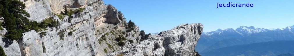
départ du petit village de Laboule dans l%u2019Ardèche pour cette boucle sur la plaine redonde le rocher des barres et le col des langoustines dans le Tanargue.
une vue magnifique à 360° sur les massifs environnants du Vercors au mont Lozère. à faire par un jour de grand beau comme ce jour de début septembre.
 Actions
15.4 km

+771 m
/-775 m
05:21

Cliquez pour activer


Cliquez et déplacez la souris sur le profil pour analyser un tronçon (2 doigts sur mobile)
Commentaires
Pas encore de commentaire, connectez-vous pour en ajouter un.
Connectez-vous pour ajouter un commentaire
Longueur et nombre de points

15.45 km

1769 pts
Denivelé et altitude
Calculés avec un seuil de 10 mètres et un lissage sur 5 points

770 m

776 m

1411 m

672 m

1089 m
Date et durée

06 septembre 2016
08:28

06 septembre 2016
16:24

07:56:49

05:21:06

02:35:43
Vitesses et denivelés horaires

2.9 km/h
Détail »

4.9 km/h
au km 12.3

308 m/h
2h25m45s

-329 m/h
2h15m52s
| km | Temps | Vitesse | Pause |
|---|
| 1 | 23'04" | 2.6 km/h | |
| 2 | 22'55" | 2.6 km/h | 06'00" |
| 3 | 31'49" | 1.9 km/h | 20'41" |
| 4 | 37'46" | 1.6 km/h | 02'44" |
| 5 | 25'47" | 2.3 km/h | 17'48" |
| 6 | 22'52" | 2.6 km/h | 93'26" |
| 7 | 18'14" | 3.3 km/h | |
| 8 | 17'52" | 3.4 km/h | |
| 9 | 17'18" | 3.5 km/h | |
| 10 | 17'48" | 3.4 km/h | 03'29" |
| 11 | 16'26" | 3.7 km/h | |
| 12 | 16'39" | 3.6 km/h | 01'52" |
| 13 | 14'43" | 4.1 km/h | |
| 14 | 14'31" | 4.1 km/h | |
| 15 | 16'12" | 3.7 km/h | |
Dépense calorique (estimation)

580 Cal
108 Cal/h
Plus

Affichée 1403 fois et téléchargée 120 fois depuis le 07.04.20 15:25
KME
25.7 kilomètres effort
Carte + Profil [Afficher un aperçu]
<iframe src="https://www.visugpx.com/iITxc58rTO?iframe" allowfullscreen style="border: 0;width: 100%; height: 540px;" loading="lazy" scrolling="no"></iframe>
Carte uniquement [Afficher un aperçu]
<iframe src="https://www.visugpx.com/iITxc58rTO?iframe&maponly" allowfullscreen style="border: 0;width: 100%; height: 540px;" loading="lazy" scrolling="no"></iframe>

 ForumsToposLes plus belles randosSegments
 Offre Premium
 Connexion


 78
78 165
165 120 [Légende]


